Search
Close this search box.

We are creating some awesome events for you. Kindly bear with us.

DATOS Project utilises data science techniques for geospatial outputs

Credit: Department of Science and Technology-Advanced Science and Technology Institute

The Remote Sensing and Data Science: DATOS Help Desk (DATOS Project) is the geospatial applications initiative of the Department of Science and Technology-Advanced Science and Technology Institute (DOST-ASTI).

It is funded by the Department of Science and Technology-Philippine Council for Industry, Energy, and Emerging Technology Research and Development (DOST-PCIEERD).

How does it work?

According to a recent press release, DATOS project applies Artificial Intelligence (AI), machine learning, and other data science techniques to remotely sensed data.

On top of these, it also uses Remote Sensing (RS) and Geographic Information System (GIS) to produce geospatial outputs that can be used for disasters, agriculture and other purposes.

The geospatial outputs come from data from the DOST-ASTI’s increasingly extensive collection of data and infrastructure for data science. Add to that the data produced by previous DOST projects.

The following are some of DOST-ASTI’s data and infrastructure for data science:

  1. The Philippine Earth Data Resources Observation (PEDRO) Centre is the ground-receiving station for images from the Diwata micro-satellites and other commercial satellites that the Agency is subscribed to.
  2. There are over 2,000 automated hydro-meteorological sensors that were deployed by the Agency to collect near real time weather and water level data from all over the country.
  3. The Computing and Archiving Research Environment (COARE) Facility archives and processes all the aforementioned satellite images and weather data.
  4. The Philippine Research, Education, and Government Information Network (PREGINET) is the Philippines’ only research and education network that interconnects academic, research, government institutions and international RENs.

Benefits of DATOS

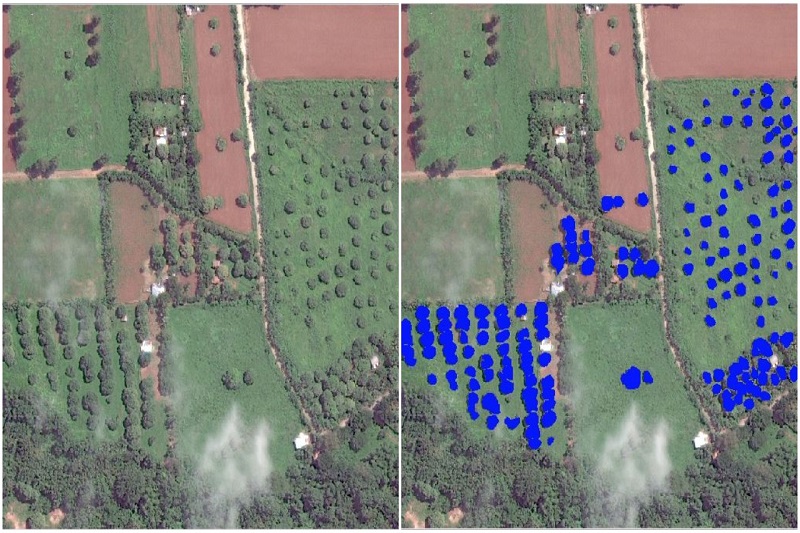
The DATOS Project, for instance, has developed a way to map out crops by using satellite images and by extracting the temporal signature of crops determined through radar satellite images.

The temporal signature is similar to a voice recognition technique wherein different words with varying lengths can be identified as the same word.

A standing partnership with the Sugar Regulatory Administration (SRA) exists in order to help automate the mapping of sugarcane plantations for yield prediction and disaster monitoring.

The same methodology can be used to map out other crops with known temporal signature such as rice and corn.

Moreover, DATOS produces flood situation maps by retrieving satellite images and letting AI identify flooded areas from these imageries.

DATOS is able to detect floods in areas that are hit by heavy rainfall and sends these mapped out areas to the respective DOST regional offices in the event of severe weather disturbances.

AI is also being used to detect objects from satellite images.

An example of which is the current partnership with the Bataan Peninsula State University in order to help the institution automate the mapping of their province’s mango trees.

Other objects that have been detected by the project from satellite images using AI include road networks, ships, land cover classes, and built-up areas.

The Agency responsible for DATOS

The DOST-ASTI is an attached agency of the Department of Science and Technology (DOST) that undertakes scientific research and development and technology transfer in the advanced fields of Information and Communication Technology (ICT), computing, electronics and their applications.

It continues to dedicate itself to developing and delivering technology solutions to enable a productive, globally competitive and resilient Filipino society.

PARTNER

Qlik’s vision is a data-literate world, where everyone can use data and analytics to improve decision-making and solve their most challenging problems. A private company, Qlik offers real-time data integration and analytics solutions, powered by Qlik Cloud, to close the gaps between data, insights and action. By transforming data into Active Intelligence, businesses can drive better decisions, improve revenue and profitability, and optimize customer relationships. Qlik serves more than 38,000 active customers in over 100 countries.

PARTNER

CTC Global Singapore, a premier end-to-end IT solutions provider, is a fully owned subsidiary of ITOCHU Techno-Solutions Corporation (CTC) and ITOCHU Corporation.

Since 1972, CTC has established itself as one of the country’s top IT solutions providers. With 50 years of experience, headed by an experienced management team and staffed by over 200 qualified IT professionals, we support organizations with integrated IT solutions expertise in Autonomous IT, Cyber Security, Digital Transformation, Enterprise Cloud Infrastructure, Workplace Modernization and Professional Services.

Well-known for our strengths in system integration and consultation, CTC Global proves to be the preferred IT outsourcing destination for organizations all over Singapore today.

PARTNER

Planview has one mission: to build the future of connected work. Our solutions enable organizations to connect the business from ideas to impact, empowering companies to accelerate the achievement of what matters most. Planview’s full spectrum of Portfolio Management and Work Management solutions creates an organizational focus on the strategic outcomes that matter and empowers teams to deliver their best work, no matter how they work. The comprehensive Planview platform and enterprise success model enables customers to deliver innovative, competitive products, services, and customer experiences. Headquartered in Austin, Texas, with locations around the world, Planview has more than 1,300 employees supporting 4,500 customers and 2.6 million users worldwide. For more information, visit www.planview.com.

SUPPORTING ORGANISATION

SIRIM is a premier industrial research and technology organisation in Malaysia, wholly-owned by the Minister​ of Finance Incorporated. With over forty years of experience and expertise, SIRIM is mandated as the machinery for research and technology development, and the national champion of quality. SIRIM has always played a major role in the development of the country’s private sector. By tapping into our expertise and knowledge base, we focus on developing new technologies and improvements in the manufacturing, technology and services sectors. We nurture Small Medium Enterprises (SME) growth with solutions for technology penetration and upgrading, making it an ideal technology partner for SMEs.

PARTNER

HashiCorp provides infrastructure automation software for multi-cloud environments, enabling enterprises to unlock a common cloud operating model to provision, secure, connect, and run any application on any infrastructure. HashiCorp tools allow organizations to deliver applications faster by helping enterprises transition from manual processes and ITIL practices to self-service automation and DevOps practices. 

PARTNER

IBM is a leading global hybrid cloud and AI, and business services provider. We help clients in more than 175 countries capitalize on insights from their data, streamline business processes, reduce costs and gain the competitive edge in their industries. Nearly 3,000 government and corporate entities in critical infrastructure areas such as financial services, telecommunications and healthcare rely on IBM’s hybrid cloud platform and Red Hat OpenShift to affect their digital transformations quickly, efficiently and securely. IBM’s breakthrough innovations in AI, quantum computing, industry-specific cloud solutions and business services deliver open and flexible options to our clients. All of this is backed by IBM’s legendary commitment to trust, transparency, responsibility, inclusivity and service.