Search
Close this search box.

We are creating some awesome events for you. Kindly bear with us.

HK’s 3D Mapping Tech Pushing Smart City Goals

Hong Kong 3D Mapping Technology
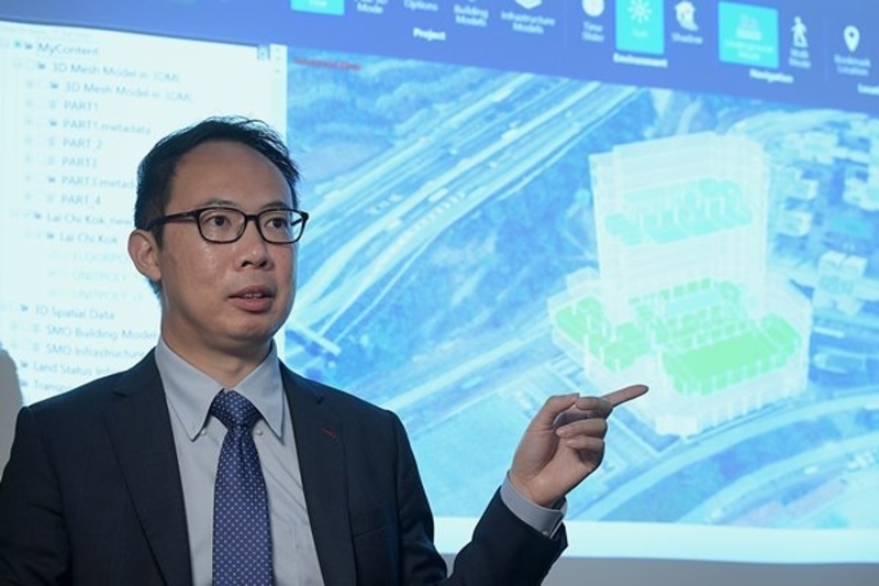
Image Credits: HKSAR Government, Press Release

Hongkongers will probably have seen a distinctive white car, fitted with advanced imaging and sensory gadgetry, making its way around the city, creating the next generation of Hong Kong maps.

As it travels up and down the city’s streets, the vehicle records the three-dimensional shapes of buildings ranging from the iconic Convention & Exhibition Centre to the Customs Headquarters Building, and even primary school campuses.

 3D Mapping Vehicle
The 3D mapping vehicle making its journey through HK.
Source: HKSAR Government, Press Release.

The vehicle, dubbed the Mobile Mapping System, is one of the latest technologies used by the Lands Department to survey the city.

Five pieces of equipment work in concert to collect detailed information for the 3D City Map – a core component of the digital infrastructure underpinning Hong Kong’s smart city development.

A high-resolution camera on top of the vehicle captures 360-degree images and a 3D laser scanner collects spatial measurements.

An inertial navigation system and a global navigation satellite system receiver provide precise positioning.

The Assistant Land Surveyor of the Lands Department stated that said one of the biggest advantages of this system is its ability to quickly and efficiently acquire data, which can be used to enrich 3D models and enhance existing maps.

Using the technology, the department can enhance the attributed information of its basic map. For example, the lamppost number, the building name or the street number.

Drones are also used to map the city, she added. However, air surveying may not be suitable for collecting data from ground level. This is where the Mobile Mapping System vehicle comes into play.

Better Data

  • The 3D City Map is part of the 3D Digital Map Development, which aims to contribute to an innovative, sustainable and smart Hong Kong.
  • Compared with traditional maps, the 3D City Map can provide more accurate and abundantly better spatial data.
  • The map will cover the entire city by 2023, serving as a handy tool for analysis and planning, according to the Lands Department’s Land Surveyor.
  • He stated that based on the 3D digital map, we can develop various kinds of applications such as land administration, environmental assessment, town planning and also transport and engineering studies.
  • The latest transport infrastructures such as the Hong Kong-Zhuhai-Macao Bridge, the Central-Wan Chai Bypass and the Heung Yuen Wai Highway have also been scanned.
  • In the next stage of the 3D Digital Map Development, the department will create the 3D Indoor Map. As a start, data from 150 buildings in Kowloon East will be collected first before extending to other buildings in the city.
  • The last stage 3D models of objects such as trees and lampposts for city modelling will be produced.
  • According to an earlier report, Hong Kong’s 3D-mapping system has allowed Hong Kong authorities to plan and visualise the dense urban environment in a faster and easier way.
  • The tool caters to the needs of a greying population amid rising demand for urban redevelopment. Before the roll-out of the system, planners had to spend days on different platforms and software generating assessments for a multitude of urban environmental issues.
  • Another advantage of the system is that it acts as a one-stop portal, embedded with all kinds of data ranging from population trends to building heights.
  • Such information allows preliminary analyses of how a proposed building will impact the neighbouring environment, with assessments of air ventilation and even whether it would affect the view of neighbouring blocks.
PARTNER

Qlik’s vision is a data-literate world, where everyone can use data and analytics to improve decision-making and solve their most challenging problems. A private company, Qlik offers real-time data integration and analytics solutions, powered by Qlik Cloud, to close the gaps between data, insights and action. By transforming data into Active Intelligence, businesses can drive better decisions, improve revenue and profitability, and optimize customer relationships. Qlik serves more than 38,000 active customers in over 100 countries.

PARTNER

CTC Global Singapore, a premier end-to-end IT solutions provider, is a fully owned subsidiary of ITOCHU Techno-Solutions Corporation (CTC) and ITOCHU Corporation.

Since 1972, CTC has established itself as one of the country’s top IT solutions providers. With 50 years of experience, headed by an experienced management team and staffed by over 200 qualified IT professionals, we support organizations with integrated IT solutions expertise in Autonomous IT, Cyber Security, Digital Transformation, Enterprise Cloud Infrastructure, Workplace Modernization and Professional Services.

Well-known for our strengths in system integration and consultation, CTC Global proves to be the preferred IT outsourcing destination for organizations all over Singapore today.

PARTNER

Planview has one mission: to build the future of connected work. Our solutions enable organizations to connect the business from ideas to impact, empowering companies to accelerate the achievement of what matters most. Planview’s full spectrum of Portfolio Management and Work Management solutions creates an organizational focus on the strategic outcomes that matter and empowers teams to deliver their best work, no matter how they work. The comprehensive Planview platform and enterprise success model enables customers to deliver innovative, competitive products, services, and customer experiences. Headquartered in Austin, Texas, with locations around the world, Planview has more than 1,300 employees supporting 4,500 customers and 2.6 million users worldwide. For more information, visit www.planview.com.

SUPPORTING ORGANISATION

SIRIM is a premier industrial research and technology organisation in Malaysia, wholly-owned by the Minister​ of Finance Incorporated. With over forty years of experience and expertise, SIRIM is mandated as the machinery for research and technology development, and the national champion of quality. SIRIM has always played a major role in the development of the country’s private sector. By tapping into our expertise and knowledge base, we focus on developing new technologies and improvements in the manufacturing, technology and services sectors. We nurture Small Medium Enterprises (SME) growth with solutions for technology penetration and upgrading, making it an ideal technology partner for SMEs.

PARTNER

HashiCorp provides infrastructure automation software for multi-cloud environments, enabling enterprises to unlock a common cloud operating model to provision, secure, connect, and run any application on any infrastructure. HashiCorp tools allow organizations to deliver applications faster by helping enterprises transition from manual processes and ITIL practices to self-service automation and DevOps practices. 

PARTNER

IBM is a leading global hybrid cloud and AI, and business services provider. We help clients in more than 175 countries capitalize on insights from their data, streamline business processes, reduce costs and gain the competitive edge in their industries. Nearly 3,000 government and corporate entities in critical infrastructure areas such as financial services, telecommunications and healthcare rely on IBM’s hybrid cloud platform and Red Hat OpenShift to affect their digital transformations quickly, efficiently and securely. IBM’s breakthrough innovations in AI, quantum computing, industry-specific cloud solutions and business services deliver open and flexible options to our clients. All of this is backed by IBM’s legendary commitment to trust, transparency, responsibility, inclusivity and service.