Search
Close this search box.

We are creating some awesome events for you. Kindly bear with us.

India Launches Spatial Planning App

India Gram Manchitra Application Launch
Image credit: mopr goi; Twitter

The Union Minister for Rural Development launched the Gram Manchitra application at the National Panchayat Awards 2019 in New Delhi, earlier this week.

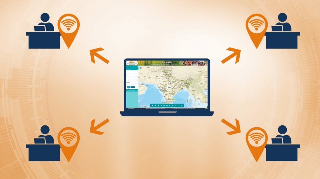
The Gram Manchitra application is a spatial planning tool that was developed by the National Informatics Centre (NIC). Village councils can use the India gram manchitra application to plan, develop, and monitor developmental activities in real-time.

It aims to promote digitalisation and e-governance at the grass-root level.

India Gram Manchitra Application
The Gram Manchitra app aims to promote digitalisation and e-governance at the grass-root level. [Image credit: mopr_goi; Twitter]
The India spatial planning app is based on NIC’s multilayer GIS platform Bharat Maps.

According to the government, the Digital India initiative aims to establish an end-to-end geospatial electronics delivery system as part of the Mission Mode Projects in the e-governance domain.

The national GIS mission is the foundation for the location-based electronic delivery of services for planning and governance.

Bharat Maps is an integrated base map service that uses a 1:50,000 scale reference data from the Survey of India (SOI) and Indian Space Research Organisation (ISRO), among others. This encompasses 23 layers containing administrative boundaries, transport layers such as roads and railways, forest layers, and settlement locations.

Last month, the government launched a drone-powered digital maps project.

Under the project, SOI, with support from the Department of Science and Technology (DST), will digitally map the length and breadth of the country over the next two years.

Unlike the global positioning systems (GPS), which is a satellite-based navigation system, the digital maps for India are likely to be more accurate and precise.

The resolution of the map is five centimetres (cm), which means that one pixel will represent five cm on the ground. For accuracy, SOI needs at least two pixels, meaning the accuracy of the map will be 10 cm.

For national security, sensitive areas like defence bases will be edited out of the maps. SOI will prepare two series of maps; the open series map (OSM) for civilian uses or open uses and the defence series map (DSM) for defence uses only.

The drones will have sensors with Indian and global reference points programmed into them. When they take images of the ground, they can tell the exact longitude and latitude of that place.

The maps could be used for urban planning and other ground utility projects. For example, if a panchayat (village) has to make a pond, it will know where the low-lying areas are and plan it accordingly to ensure maximum water retention, the surveyor-general of India explained.

The idea is to make digital maps available to everyone. The mapping is drone-based but will be corroborated with ground-based information.

SOI has over 2,500 ground control points, uniformly distributed throughout the country and of which the standardised coordinates are known. However, the new mapping will be supported by a network of continuously operating reference stations (CORS) for instant online 3D positioning.

The objective is to generate digital maps on a 1:500 scale. So far, it maintains topographic maps in 1:5,000,000 and partially in 1:2,500,000 and 1:1,000,000 scales.

The SOI also plans to map floodplains of the river Ganga and 25 kilometres around the region. The map will help researchers gather information about the source of discharge, erosion, and elevation on both sides of the plain. It will also help predict flooding patterns.

The DST is preparing a draft geospatial data policy that will cover who can own geospatial data, how they can use it, and how it can be shared.

The policy will be put in the public domain for consultation soon. It will set a balance between security and products for advancement.

PARTNER

Qlik’s vision is a data-literate world, where everyone can use data and analytics to improve decision-making and solve their most challenging problems. A private company, Qlik offers real-time data integration and analytics solutions, powered by Qlik Cloud, to close the gaps between data, insights and action. By transforming data into Active Intelligence, businesses can drive better decisions, improve revenue and profitability, and optimize customer relationships. Qlik serves more than 38,000 active customers in over 100 countries.

PARTNER

CTC Global Singapore, a premier end-to-end IT solutions provider, is a fully owned subsidiary of ITOCHU Techno-Solutions Corporation (CTC) and ITOCHU Corporation.

Since 1972, CTC has established itself as one of the country’s top IT solutions providers. With 50 years of experience, headed by an experienced management team and staffed by over 200 qualified IT professionals, we support organizations with integrated IT solutions expertise in Autonomous IT, Cyber Security, Digital Transformation, Enterprise Cloud Infrastructure, Workplace Modernization and Professional Services.

Well-known for our strengths in system integration and consultation, CTC Global proves to be the preferred IT outsourcing destination for organizations all over Singapore today.

PARTNER

Planview has one mission: to build the future of connected work. Our solutions enable organizations to connect the business from ideas to impact, empowering companies to accelerate the achievement of what matters most. Planview’s full spectrum of Portfolio Management and Work Management solutions creates an organizational focus on the strategic outcomes that matter and empowers teams to deliver their best work, no matter how they work. The comprehensive Planview platform and enterprise success model enables customers to deliver innovative, competitive products, services, and customer experiences. Headquartered in Austin, Texas, with locations around the world, Planview has more than 1,300 employees supporting 4,500 customers and 2.6 million users worldwide. For more information, visit www.planview.com.

SUPPORTING ORGANISATION

SIRIM is a premier industrial research and technology organisation in Malaysia, wholly-owned by the Minister​ of Finance Incorporated. With over forty years of experience and expertise, SIRIM is mandated as the machinery for research and technology development, and the national champion of quality. SIRIM has always played a major role in the development of the country’s private sector. By tapping into our expertise and knowledge base, we focus on developing new technologies and improvements in the manufacturing, technology and services sectors. We nurture Small Medium Enterprises (SME) growth with solutions for technology penetration and upgrading, making it an ideal technology partner for SMEs.

PARTNER

HashiCorp provides infrastructure automation software for multi-cloud environments, enabling enterprises to unlock a common cloud operating model to provision, secure, connect, and run any application on any infrastructure. HashiCorp tools allow organizations to deliver applications faster by helping enterprises transition from manual processes and ITIL practices to self-service automation and DevOps practices. 

PARTNER

IBM is a leading global hybrid cloud and AI, and business services provider. We help clients in more than 175 countries capitalize on insights from their data, streamline business processes, reduce costs and gain the competitive edge in their industries. Nearly 3,000 government and corporate entities in critical infrastructure areas such as financial services, telecommunications and healthcare rely on IBM’s hybrid cloud platform and Red Hat OpenShift to affect their digital transformations quickly, efficiently and securely. IBM’s breakthrough innovations in AI, quantum computing, industry-specific cloud solutions and business services deliver open and flexible options to our clients. All of this is backed by IBM’s legendary commitment to trust, transparency, responsibility, inclusivity and service.