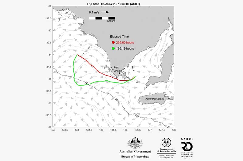
Above image: Optimal ship routing of tuna pen towing/ Credit: SARDI
Researchers from the South Australian Research and Development Institute (SARDI[1]), the research division of Primary Industries and Regions South Australia (SA) have developed a mapping system to forecast ocean currents in real-time and high resolution. The technology has been developed in partnership with the Bureau of Meteorology and the University of Adelaide.
The project was funded by the Australian Government’s Fisheries Research and Development Corporation and the Australian Southern Bluefin Tuna Industry Association.
The eSA-Marine website provides fishers, surfers, emergency services and marine personnel with forecasts of sea level, water temperature, ocean currents and wind direction and speed.
The technology can be accessed from any computer or mobile device and will be used for a range of purposes such as:
- predicting the trajectories of harmful algal blooms/toxins to allow for mitigation
- saving vessel fuel through the prediction of environmental variables important to fishery habitat
- predicting marine heat waves and possible fish mass mortalities
- predicting ocean conditions to help with aquaculture and maritime maintenance
- predicting storm surges and flooding
- helping ship routing to save fuel
- helping with search and rescue efforts
- research into ocean circulation and marine ecosystems
The website uses real-time satellite data to capture ocean forecasts ranging from Portland, Victoria, to Thevenard in South Australia’s west, and includes gulfs, shelves and deep waters of the continental slope.
The only other place in Australia to utilise this kind of e-mapping technology is the Great Barrier Reef.
In the past manual techniques have been used to monitor ocean currents, such as dropping tags – called drift cards – into the ocean from the air to see where they wash up.
The eSA-Marine system uses a nested model approach where now-cast/forecast oceanic information is telescoped down though 3 grid scales: 1) 10 km global Ocean MAPS model; 2) 2.5 km Southern Australian Regional Ocean Model (SAROM); and 3) 500 m Two Gulfs Model (TGM).
The figure above demonstrates optimal ship routing for tuna pen towing. Southern Bluefin Tuna (SBT) are caught as juveniles during December to March in a region that extends from the mid-Great Australian Bight (GAB) to Kangaroo Island. The fish are then enclosed in very large pens and towed back to Port Lincoln at speeds less than than 1 knot (0.5 m/s) relative to the ocean currents so as to avoid bruising. The passage times can exceed 10 days.
If the vessels and pens can “surf” the ocean currents then possibly there are routes that save time, fuel and money. In fact using the now-cast/forecasts, a mathematically optimal shortest route in time (and distance) can be determined. The optimal route must also assume some shallowest allowed depth (here 40 m) so as not to run aground. The green fastest route in the figure is much longer in distance but takes advantage of offshore currents that help move the green “vessel” offshore and then to the south-east. The inshore red “vessel” has opposing currents that slow it down leading to an extra 40 hours of transit time.
The South Australian Minister for Agriculture, Food and Fisheries, Leon Bignell said, “Having real-time information about ocean conditions at the touch of a button will have huge benefits for users of our marine environments in South Australia, including recreational and commercial fisheries and aquaculture.”
“Now with the eSA-Marine website we can predict how extreme weather conditions will affect the ocean, track pathogens and pollutants and even help with search and rescue efforts. It’s amazing how far the technology has come and I look forward to seeing how the eSA-Marine website is utilised by our local maritime industries to enhance safety, reduce transit times and fuel efficiency in our fisheries and improve management of aquaculture sites,” he added.
“eSA-Marine is a unique forecast system, and is in fact one of only two in-shore ocean data assimilating forecast systems in Australia,” said SARDI researcher, Professor John Middleton.
The CEO of the Australian Southern Bluefin Tuna Industry Association, Brian Jeffriess, commented, “Fishing each year in the Great Australian Bight is made difficult by the huge size of the Bight, the rough weather and the tuna moving all the time in water temperature fronts. The eSA-Marine technology and high service quality gives us the capacity to target particular fish sizes and use a lot less fuel.”
[1]The South Australian Research and Development Institute (SARDI) is a state government funded institute, which delivers practical, industry-focused solutions to primary producers, commercial partners, aquatic and natural resources managers, and other bioscience partners.