Search
Close this search box.

We are creating some awesome events for you. Kindly bear with us.

Updated mapping information provides status of land use in Australia

Updated mapping information provides status of land use in Australia

Featured image
by ABARES. 

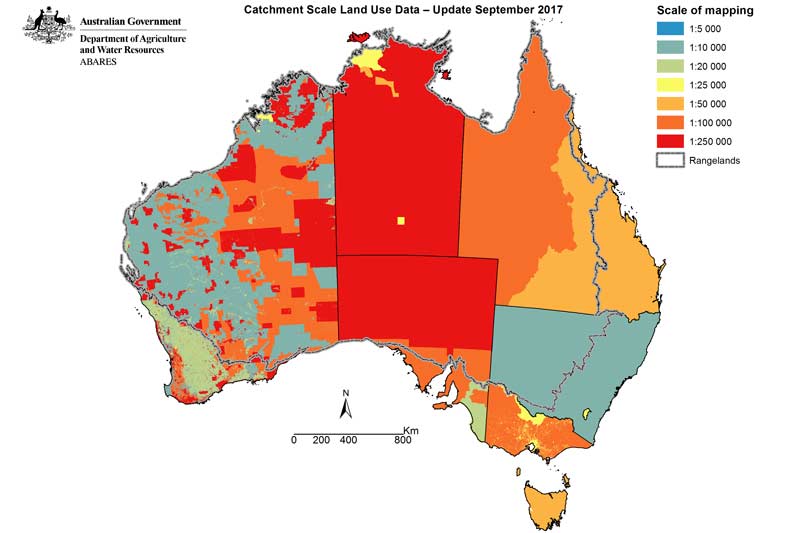
Over 585 million hectares, or 76%, of Australia’s land use mapping information
has been updated for the Catchment scale land use of Australia – Update
September 2017.

Australian Bureau of Agricultural and Resource Economics (ABARES)
Executive Director, Steve Hatfield-Dodds, said the updated data is the best
available for Australia’s regions.

“This update improves the currency of land mapping
information released in May 2016. These land use data products are recognised
as foundational spatial data for Australia, by showing the location and extent
of how we use the landscape,” Dr. Hatfield-Dodds said.

“Comprehensive land use mapping informs and supports
innovative and prompt responses to economic, social and environmental
challenges facing the agricultural sector.

“Some of these challenges arise in the scope of productivity
and sustainability, biodiversity, conservation, land use planning, natural
disaster management and natural resource investment and management.”

According to the media
release
, land use data resources are developed by ABARES with national,
state and territory agencies as part of the Australian Collaborative Land Use
and Management Program (ACLUMP),
with the support of the Department of Agriculture and Water Resources.

“Land use is mapped using high resolution imagery and is
then verified through local, expert and industry input and field validation.
The data has a currency of 2003 to 2017 (reflecting when an area was last
mapped) and a scale of 1:5,000 to 1:250,000.

“Land use is mapped according to the Australian Land Use and
Management Classification version 8, released in October 2016. Primary,
secondary and tertiary classes describe the use of land for conservation and
natural environments, production from dryland or irrigated agriculture and
plantations, intensive uses and water features.”

The following areas have been updated since the May 2016
release of the Catchment Scale Land Use of Australia dataset:

  • Desert Channels and Mackay-Whitsundays natural resource management (NRM) regions in Queensland
  • The Adelaide and Mount Lofty Ranges NRM region in South Australia (extending into part of the Murray-Darling Basin NRM region)
  • The state of New South Wales
  • The state of Victoria
  • The state of Tasmania
  • The state of Western Australia
  • The Northern Territory.

Complementing the Catchment Scale Land Use of
Australia 
is the first release of a commodities dataset - the Catchment
Scale Land Use of Australia – Commodities – September 2017
. This commodity
information can be extracted or combined with other spatial datasets to provide
new insights and analysis concerning land use in Australia.

Agricultural commodity level mapping is available for all of
the Northern Territory, and for the following commodities nationally (as at the
date mapped):

  • Crops  – rice, sugar cane, cotton
  • Fruit   – bananas (except Southern Queensland), avocados, mangoes, olives, grapes
  • Nuts   – macadamias
  • Livestock  – dairy cattle, pigs, poultry, horse studs, aquaculture.

The focus of this first release of commodities data has been
horticultural and intensive animal industries to support biosecurity
preparedness and response.

These two national datasets and the original individual
state and territory data (from which the national datasets were derived) are
accessible to download via Land
usee data download
.

PARTNER

Qlik’s vision is a data-literate world, where everyone can use data and analytics to improve decision-making and solve their most challenging problems. A private company, Qlik offers real-time data integration and analytics solutions, powered by Qlik Cloud, to close the gaps between data, insights and action. By transforming data into Active Intelligence, businesses can drive better decisions, improve revenue and profitability, and optimize customer relationships. Qlik serves more than 38,000 active customers in over 100 countries.

PARTNER

CTC Global Singapore, a premier end-to-end IT solutions provider, is a fully owned subsidiary of ITOCHU Techno-Solutions Corporation (CTC) and ITOCHU Corporation.

Since 1972, CTC has established itself as one of the country’s top IT solutions providers. With 50 years of experience, headed by an experienced management team and staffed by over 200 qualified IT professionals, we support organizations with integrated IT solutions expertise in Autonomous IT, Cyber Security, Digital Transformation, Enterprise Cloud Infrastructure, Workplace Modernization and Professional Services.

Well-known for our strengths in system integration and consultation, CTC Global proves to be the preferred IT outsourcing destination for organizations all over Singapore today.

PARTNER

Planview has one mission: to build the future of connected work. Our solutions enable organizations to connect the business from ideas to impact, empowering companies to accelerate the achievement of what matters most. Planview’s full spectrum of Portfolio Management and Work Management solutions creates an organizational focus on the strategic outcomes that matter and empowers teams to deliver their best work, no matter how they work. The comprehensive Planview platform and enterprise success model enables customers to deliver innovative, competitive products, services, and customer experiences. Headquartered in Austin, Texas, with locations around the world, Planview has more than 1,300 employees supporting 4,500 customers and 2.6 million users worldwide. For more information, visit www.planview.com.

SUPPORTING ORGANISATION

SIRIM is a premier industrial research and technology organisation in Malaysia, wholly-owned by the Minister​ of Finance Incorporated. With over forty years of experience and expertise, SIRIM is mandated as the machinery for research and technology development, and the national champion of quality. SIRIM has always played a major role in the development of the country’s private sector. By tapping into our expertise and knowledge base, we focus on developing new technologies and improvements in the manufacturing, technology and services sectors. We nurture Small Medium Enterprises (SME) growth with solutions for technology penetration and upgrading, making it an ideal technology partner for SMEs.

PARTNER

HashiCorp provides infrastructure automation software for multi-cloud environments, enabling enterprises to unlock a common cloud operating model to provision, secure, connect, and run any application on any infrastructure. HashiCorp tools allow organizations to deliver applications faster by helping enterprises transition from manual processes and ITIL practices to self-service automation and DevOps practices. 

PARTNER

IBM is a leading global hybrid cloud and AI, and business services provider. We help clients in more than 175 countries capitalize on insights from their data, streamline business processes, reduce costs and gain the competitive edge in their industries. Nearly 3,000 government and corporate entities in critical infrastructure areas such as financial services, telecommunications and healthcare rely on IBM’s hybrid cloud platform and Red Hat OpenShift to affect their digital transformations quickly, efficiently and securely. IBM’s breakthrough innovations in AI, quantum computing, industry-specific cloud solutions and business services deliver open and flexible options to our clients. All of this is backed by IBM’s legendary commitment to trust, transparency, responsibility, inclusivity and service.