

|
Getting your Trinity Audio player ready...
|
Australian scientists are making significant strides in the rapid detection of bushfires, leveraging cube satellites equipped with onboard artificial intelligence to enhance detection speeds by up to 500 times compared to traditional ground-based imagery processing. Remote sensing and computer science researchers have successfully tackled the challenges associated with processing and compressing vast quantities of hyperspectral imagery on board smaller, more economical cube satellites. This advancement not only saves critical time but also conserves energy.
The integration of AI into these satellites represents a major breakthrough, enabling earlier detection of bushfires from space. This capability allows on-ground response teams to act more swiftly, potentially preventing the escalation of fires and minimising the loss of life and property.
A key initiative in this field is a project funded by SmartSat and led by the University of South Australia (UniSA), which has developed an energy-efficient early fire smoke detection system for South Australia’s first cube satellite, Kanyini. This mission is a collaboration between the South Australian Government, SmartSat CRC, and various industry partners. The objective is to launch a 6U CubeSat satellite into low Earth orbit to detect bushfires and monitor inland and coastal water quality.
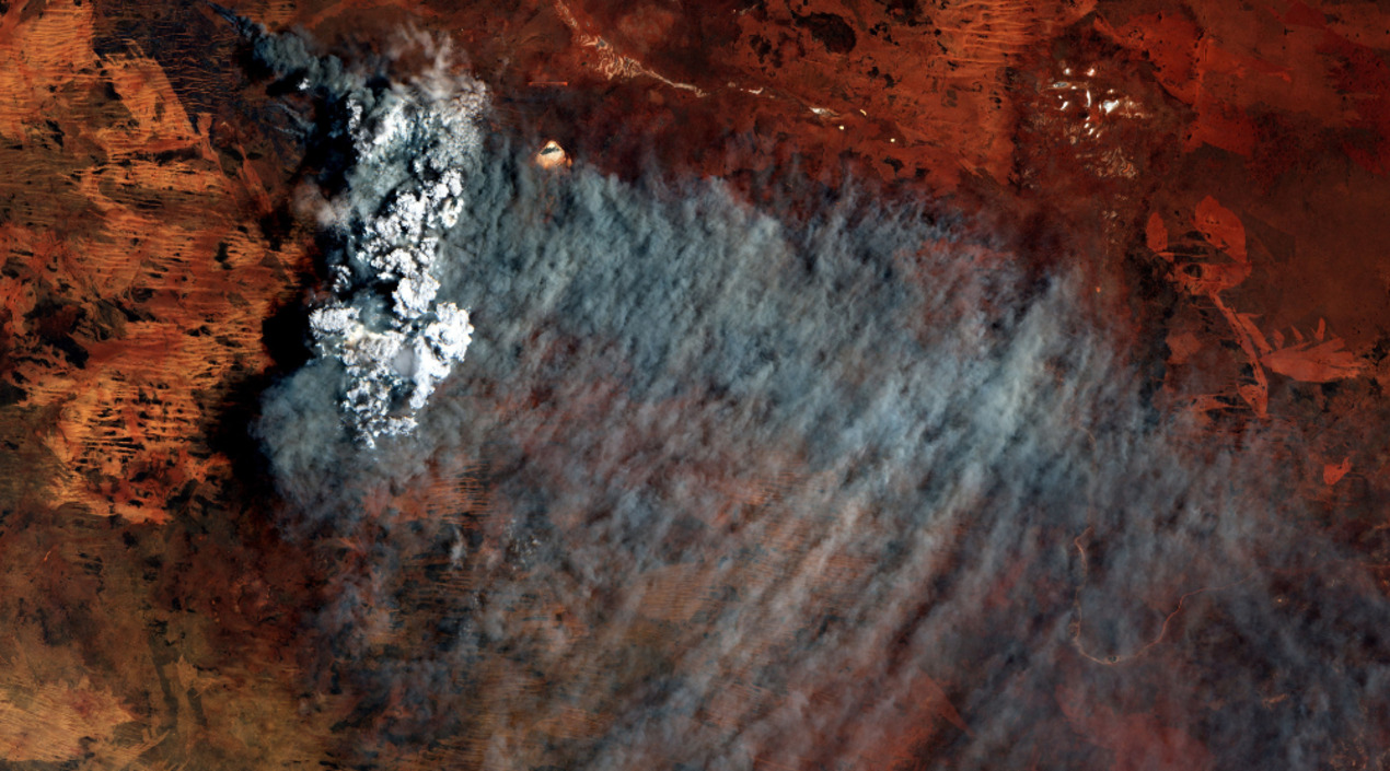
Kanyini is equipped with a hyperspectral imager, a sensor capable of capturing reflected light from Earth across various wavelengths. This capability allows for the creation of detailed surface maps applicable to several domains, including bushfire monitoring, water quality assessment, and land management.
Traditionally, Earth observation satellites have lacked the onboard processing power to analyse complex images of Earth in real-time. However, Dr. Stefan Peters, a geospatial scientist at UniSA and the project’s Lead Researcher highlights that his team has overcome this limitation by developing a lightweight AI model. This model can detect smoke while adhering to the processing, power consumption, and data storage constraints inherent in cube satellites.
The AI onboard model significantly outperforms ground-based hyperspectral satellite imagery processing in detecting fires. It reduces the volume of data downlinked to just 16% of its original size while consuming 69% less energy. Remarkably, it also detects fire smoke 500 times faster than traditional methods.
According to Dr Peters, smoke is typically the first visible sign from space before a fire grows hot and large enough for sensors to identify it, making early detection crucial. To train the AI model, the team utilised simulated satellite imagery of recent Australian bushfires, employing machine learning techniques to teach the model to recognise smoke in images.
One major challenge the researchers addressed is that only a fraction of the data collected by sensor systems pertains to the mission’s critical information. Typically, large satellites cannot process this data onboard, necessitating the downlinking of all data to ground stations for analysis, which is both space and energy-intensive. The AI model resolves this by distinguishing smoke from clouds, enhancing efficiency and speed.
Using a past fire event in the Coorong as a case study, the simulated Kanyini AI onboard approach detected smoke in less than 14 minutes and transmitted the data to the South Pole ground station. This rapid detection underscores the significant benefits of onboard AI compared to traditional ground processing, not only for bushfires but also as an early warning system for other natural disasters.
The research team anticipates demonstrating the onboard AI fire detection system in orbit in 2025 when the Kanyini mission becomes operational. Their goal is to commercialise the technology and deploy it in a CubeSat constellation, aiming for early fire detection within an hour.
The details of this experiment have been published in the latest issue of the IEEE Journal of Selected Topics in Applied Earth and Remote Sensing. This advancement marks a promising step forward in the utilisation of space-based technology for natural disaster management and prevention.