Search
Close this search box.

We are creating some awesome events for you. Kindly bear with us.

Waikato’s 3D Mapping Tech Enhancing Disaster Response

Image credits: waikatoregion.govt.nz

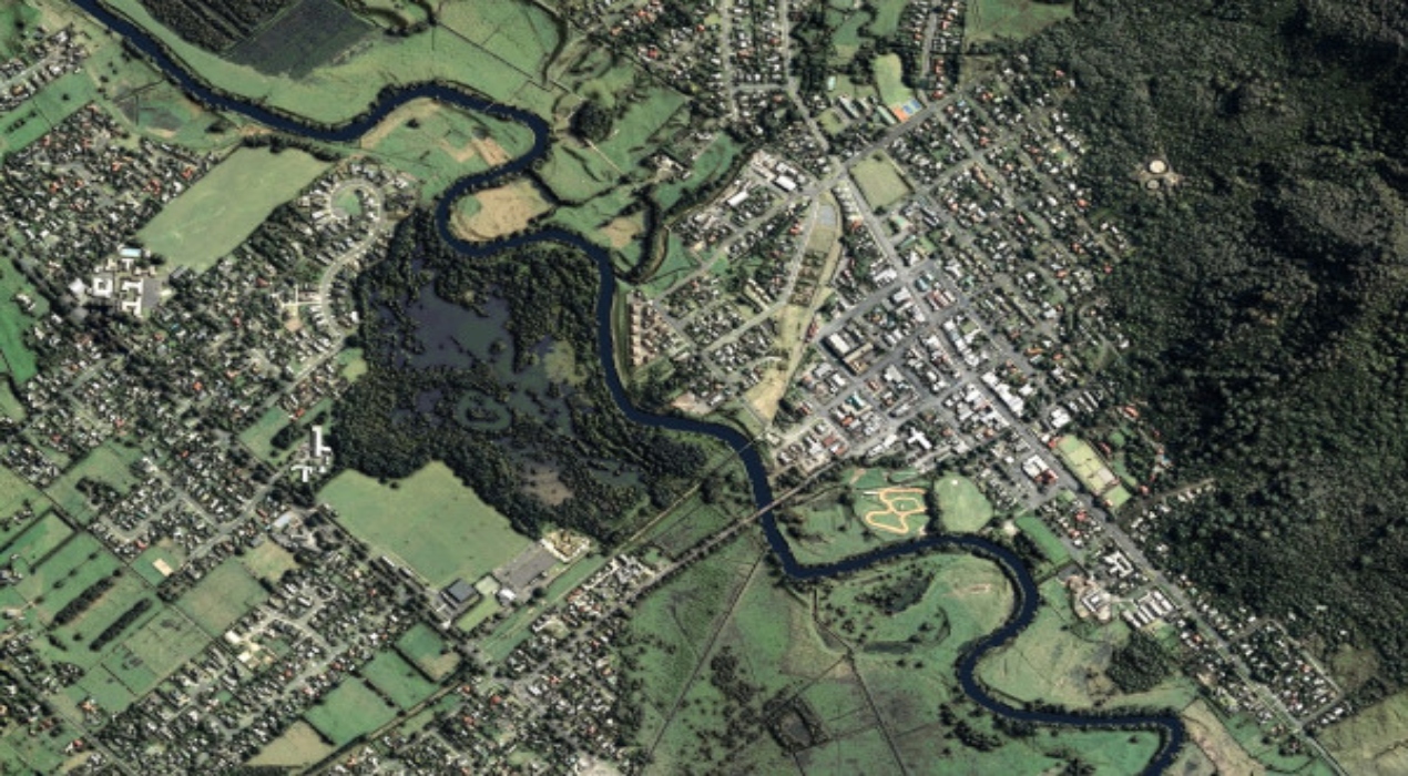
The Waikato region has recently received a boost with the release of the first highly accurate 3D mapping data collection. This development is expected to bring about a remarkable change for local councils and the entire community.

Bryan, the technical project lead, emphasised the invaluable role these maps have played in assisting the council in effectively addressing instances of flooding in Coromandel. The availability of such detailed mapping information is poised to revolutionise decision-making processes and enhance disaster response capabilities in the region.

“Right now we have engineering companies using this data to figure out where the landslips are and the volumes of material that has fallen off the side of a cliff,” he said.

Coromandel, situated on the North Island of New Zealand, is renowned for its rugged terrain and susceptible areas prone to debris and slippery surfaces, especially during rainfall. Considering this, travelers are strongly advised to steer clear of the east coast of Coromandel due to the significant flooding experienced by several coastal communities caused by heavy rainfall.

Furthermore, apart from its crucial role in disaster preparedness, this technology also holds immense potential for fostering business growth. The government can now provide comprehensive support to various business requirements at a property level, ensuring consistent coverage across the entire region.

For instance, potential investors interested in acquiring land in the area can use this technology to project and assess the land’s suitability before investing. This capability enables informed decision-making and empowers businesses to make strategic choices aligned with their goals and objectives.

Moreover, this technology empowers the government to make informed projections regarding land suitability for agricultural purposes. By harnessing advanced mapping and analysis, the government can identify areas with optimal soil quality, adequate water availability, and favourable climatic conditions, all crucial factors for successful farming. It enables them to make well-informed decisions regarding selecting the most suitable crops and maximising agricultural productivity.

By accurately projecting the potential of different land areas for farming, the government can support agricultural stakeholders in making informed choices regarding crop selection, irrigation methods, and resource allocation. Farmers and investors can benefit from this information, as it allows them to assess the viability of cultivating specific crops in certain regions, thereby minimising risks and optimising yields.

By using this technology, the Waikato Regional Council will bolster its capabilities in accurately modeling natural hazards and climate change, improving infrastructure design, facilitating more effective land use planning, and ultimately advancing environmental outcomes for the local community in the region.

The council aims to enhance its decision-making processes, enable proactive measures to mitigate risks posed by natural phenomena and promote sustainable development practices that prioritise the well-being of the environment and the community. This technological advancement signifies a notable step forward in the council’s commitment to ensuring the region’s resilient and prosperous future.

At present, 40% of New Zealand’s land area is accessible at no charge online, offering comprehensive coverage. Over 2024, the extent of national coverage is set to increase to 80% of the country’s total land area.

PARTNER

Qlik’s vision is a data-literate world, where everyone can use data and analytics to improve decision-making and solve their most challenging problems. A private company, Qlik offers real-time data integration and analytics solutions, powered by Qlik Cloud, to close the gaps between data, insights and action. By transforming data into Active Intelligence, businesses can drive better decisions, improve revenue and profitability, and optimize customer relationships. Qlik serves more than 38,000 active customers in over 100 countries.

PARTNER

CTC Global Singapore, a premier end-to-end IT solutions provider, is a fully owned subsidiary of ITOCHU Techno-Solutions Corporation (CTC) and ITOCHU Corporation.

Since 1972, CTC has established itself as one of the country’s top IT solutions providers. With 50 years of experience, headed by an experienced management team and staffed by over 200 qualified IT professionals, we support organizations with integrated IT solutions expertise in Autonomous IT, Cyber Security, Digital Transformation, Enterprise Cloud Infrastructure, Workplace Modernization and Professional Services.

Well-known for our strengths in system integration and consultation, CTC Global proves to be the preferred IT outsourcing destination for organizations all over Singapore today.

PARTNER

Planview has one mission: to build the future of connected work. Our solutions enable organizations to connect the business from ideas to impact, empowering companies to accelerate the achievement of what matters most. Planview’s full spectrum of Portfolio Management and Work Management solutions creates an organizational focus on the strategic outcomes that matter and empowers teams to deliver their best work, no matter how they work. The comprehensive Planview platform and enterprise success model enables customers to deliver innovative, competitive products, services, and customer experiences. Headquartered in Austin, Texas, with locations around the world, Planview has more than 1,300 employees supporting 4,500 customers and 2.6 million users worldwide. For more information, visit www.planview.com.

SUPPORTING ORGANISATION

SIRIM is a premier industrial research and technology organisation in Malaysia, wholly-owned by the Minister​ of Finance Incorporated. With over forty years of experience and expertise, SIRIM is mandated as the machinery for research and technology development, and the national champion of quality. SIRIM has always played a major role in the development of the country’s private sector. By tapping into our expertise and knowledge base, we focus on developing new technologies and improvements in the manufacturing, technology and services sectors. We nurture Small Medium Enterprises (SME) growth with solutions for technology penetration and upgrading, making it an ideal technology partner for SMEs.

PARTNER

HashiCorp provides infrastructure automation software for multi-cloud environments, enabling enterprises to unlock a common cloud operating model to provision, secure, connect, and run any application on any infrastructure. HashiCorp tools allow organizations to deliver applications faster by helping enterprises transition from manual processes and ITIL practices to self-service automation and DevOps practices. 

PARTNER

IBM is a leading global hybrid cloud and AI, and business services provider. We help clients in more than 175 countries capitalize on insights from their data, streamline business processes, reduce costs and gain the competitive edge in their industries. Nearly 3,000 government and corporate entities in critical infrastructure areas such as financial services, telecommunications and healthcare rely on IBM’s hybrid cloud platform and Red Hat OpenShift to affect their digital transformations quickly, efficiently and securely. IBM’s breakthrough innovations in AI, quantum computing, industry-specific cloud solutions and business services deliver open and flexible options to our clients. All of this is backed by IBM’s legendary commitment to trust, transparency, responsibility, inclusivity and service.